Lake St. Clair Sailing School — Student Reference
Navigation Chart Guide
Your complete on-water navigation reference for Lake St. Clair
Lake St. Clair Overview
Lake St. Clair is a freshwater lake situated between Ontario, Canada and Michigan, USA. It connects Lake Huron via the St. Clair River to the north and Lake Erie via the Detroit River to the south, forming a critical link in the Great Lakes waterway system.
| Characteristic | Detail |
|---|---|
| Surface area | 430 sq mi (1,114 km²) |
| Average depth | 11 ft (3.4 m) |
| Maximum depth | 27 ft (8.2 m) — main shipping channel |
| Primary inflow | St. Clair River (north) |
| Primary outflow | Detroit River (south) |
| Shared between | Michigan, USA and Ontario, Canada |
| NOAA Chart | 14850 — Lake St. Clair |
Major Regions of the Lake
Sailors commonly divide Lake St. Clair into five geographic zones:
| Zone | Location | Characteristics |
|---|---|---|
| North Basin | Near St. Clair River delta | Delta shoals, islands, marked channels — caution required |
| Central Lake | Open mid-lake | Deepest open water, primary sailing area for instruction |
| South Basin | Near Detroit River mouth | Busy commercial traffic — watch for freighters |
| Michigan Shore | Western shoreline (US) | Marina row, St. Clair Shores, heavy recreational traffic |
| Ontario Shore | Eastern shoreline (Canada) | Walpole Island, quieter waters, watch for shoals |
Charts & Navigation Resources
All vessels on Lake St. Clair should carry — or have electronic access to — the official NOAA chart. Charts are updated regularly; always verify you have the current edition before departing.
| Chart / Resource | Coverage | Source |
|---|---|---|
| NOAA Chart 14850 Primary | Full Lake St. Clair | nauticalcharts.noaa.gov |
| NOAA Chart 14849 | St. Clair River | nauticalcharts.noaa.gov |
| NOAA Chart 14848 | Detroit River / Lake Erie approach | nauticalcharts.noaa.gov |
| CHS Chart 2105 | Lake St. Clair (Canadian edition) | charts.gc.ca |
| Navionics App | Full Great Lakes — digital | navionics.com |
| C-MAP App | Full Great Lakes — digital | c-map.com |
| ActiveCaptain | Crowdsourced hazard & marina notes | activecaptain.com |
Chart Symbols You Must Know
The following symbols appear most frequently on Lake St. Clair charts. Learn these before each sailing season or when entering a new area of the lake.
| Symbol | Meaning | Action Required |
|---|---|---|
| Dark blue shading | Shallow water (under 6 ft) | Avoid — grounding risk for most keelboats |
| Light blue shading | Intermediate depth (6–18 ft) | Proceed with caution, verify current depths |
| White area | Deep / navigable water | Normal sailing area |
| Magenta circle | Buoy or beacon | Identify type by number and color |
| R with number | Red daymark / red buoy | Keep to port when returning from sea |
| G with number | Green daymark / green buoy | Keep to starboard when returning |
| Anchor symbol ⚓ | Recommended anchorage | Check holding ground before anchoring |
| Wreck symbol (Wk) | Submerged wreck | Give wide berth — hazard to navigation |
| Rock with dot (+) | Submerged rock at charted depth | Check depth; avoid in low water conditions |
| Grass / Grs | Shoal / grass bottom | Shallow — avoid with keeled vessel |
Key Waypoints & Landmarks
The following waypoints and landmarks are commonly used by Lake St. Clair sailors. Coordinates are approximate — always cross-reference with your current chart and GPS.
| Location / Landmark | Approx. Lat (N) | Approx. Long (W) | Notes |
|---|---|---|---|
| St. Clair River entrance (N) | 42° 37′ | 82° 28′ | Main inflow — strong current, watch set & drift |
| Detroit River entrance (S) | 42° 22′ | 82° 55′ | Watch for freighter traffic at all times |
| Grosse Pointe Shores | 42° 27′ | 82° 52′ | Michigan shore, breakwall clearly visible |
| St. Clair Shores | 42° 29′ | 82° 53′ | Dense marina area — heavy weekend traffic |
| Harrison Twp / Fraser Harbor | 42° 35′ | 82° 47′ | Northern Michigan marinas — sailing school base |
| Harsen’s Island (US) | 42° 34′ | 82° 34′ | Delta region — many channels, very shallow areas |
| Walpole Island (ON) | 42° 37′ | 82° 31′ | First Nations territory — approach respectfully |
| Stoney Point (ON) | 42° 25′ | 82° 41′ | Ontario east shore landmark |
| Mitchell’s Bay (ON) | 42° 28′ | 82° 32′ | Sheltered bay — popular anchorage for cruisers |
| Middle Channel (main) | 42° 30′ | 82° 40′ | Central deep water corridor — main sailing highway |
Local Marinas & Fuel Docks
| Marina | Location | Fuel | Guest Dockage |
|---|---|---|---|
| Lake St. Clair Sailing School Home Base | Harrison Twp, MI | Nearby | Check with school |
| Metro Beach Marina | Harrison Twp, MI | No | Yes |
| Selfridge Marina | Harrison Twp, MI | Yes | Limited |
| St. Clair Shores Harbor | St. Clair Shores, MI | Yes | Yes |
| Anchor Bay Yacht Club | New Baltimore, MI | Yes | Yes |
| Crooked Creek Marina | Ontario, ON | Yes | Yes |
| Mitchell’s Bay Marina | Wallaceburg, ON | Yes | Yes |
Buoys & Aids to Navigation
Lake St. Clair uses the IALA-B buoyage system, used throughout the USA and Canada on the Great Lakes. The golden rule: “Red Right Returning” — when returning from open water toward harbor, keep red buoys on your starboard (right) side.
Keep to port (returning)
Keep to starboard (returning)
Pass any side
Danger below — pass wide
Check chart for meaning
Preferred channel = top color side
Full Buoy Reference Table
| Buoy Type | Color | Shape | Light (if lit) | Action |
|---|---|---|---|---|
| Port mark | Red | Nun (cone) | Red, even flash | Keep to port — returning from sea |
| Starboard mark | Green | Can (cylinder) | Green, odd flash | Keep to starboard — returning |
| Safe water | Red/White vertical | Spherical | White Morse A (· —) | Safe water — may pass all sides |
| Isolated danger | Black/Red/Black | Pillar | White Gp Fl(2) | Pass either side — danger below |
| Special purpose | Yellow | Various | Yellow light | Check chart — area has special rules |
| Preferred channel | Red/Green bands | Nun or can | Composite group | Preferred channel on top-color side |
Weather, Currents & Hazards
Lake St. Clair’s shallow depth means it responds quickly to wind — waves can build to 3–4 ft in strong conditions despite the relatively small fetch. Summer afternoon thunderstorms are the most common hazard; monitor weather continuously.
Seasonal Weather Patterns
| Season | Prevailing Wind | Common Hazard | Avg. Water Temp |
|---|---|---|---|
| Spring | SW 10–20 kts | Fog banks, fast-moving cold fronts | 45–65°F |
| Summer | SW 8–15 kts | Afternoon thunderstorms — build quickly | 70–78°F |
| Fall | W/NW 15–25 kts | Squalls, strong gusts, cold water | 55–68°F |
| Winter | N/NW (gale force) | Ice formation — no sailing | 32–40°F |
Shoals & Shallow Areas
- The north delta (Harsen’s Island / St. Clair River mouth) is extremely shallow with numerous shifting shoals.
- Both the Michigan and Ontario shorelines extend shallow well offshore. Stay at least 0.5–1 nm from shore unless in a marked channel.
- The south end near the Detroit River entrance has shifting sandbars — always consult the most current chart edition.
Vessel Traffic
- The main shipping channel carries freighters up to 700+ ft long. Freighters have the right of way in the channel and cannot stop or maneuver quickly.
- Personal watercraft and powerboat traffic is extremely heavy on summer weekends — maintain a vigilant all-around watch at all times.
- The international border runs approximately through the center of the lake. US Customs & Border Protection and CBSA rules apply when crossing between US and Canadian waters.
Currents
- The St. Clair River current enters the north end of the lake and can run 1–3 knots. Account for set and drift when planning approaches near the river mouth.
- No significant tidal influence — water levels are driven by seasonal runoff and Great Lakes basin hydrology. Check NOAA gauge 9044049 (St. Clair) for current levels.
Rules of the Road
The COLREGS (International Regulations for Preventing Collisions at Sea) and US Inland Rules govern all vessel interactions on Lake St. Clair. Every sailor must know the right-of-way hierarchy.
Right-of-Way Hierarchy
| Priority | Vessel Type | Notes |
|---|---|---|
| 1 — Highest | Not under command | Unable to maneuver — give way immediately |
| 2 | Restricted in ability to maneuver | Dredge, survey vessel, constrained by draft in channel |
| 3 | Fishing vessel (commercial) | Engaged in fishing with gear deployed |
| 4 | Sailing vessel under sail only | Motor-sailors are considered power vessels |
| 5 | Power-driven vessel | Most recreational powerboats |
| 6 — Give way | Overtaking vessel | Any vessel overtaking must keep clear — regardless of type |
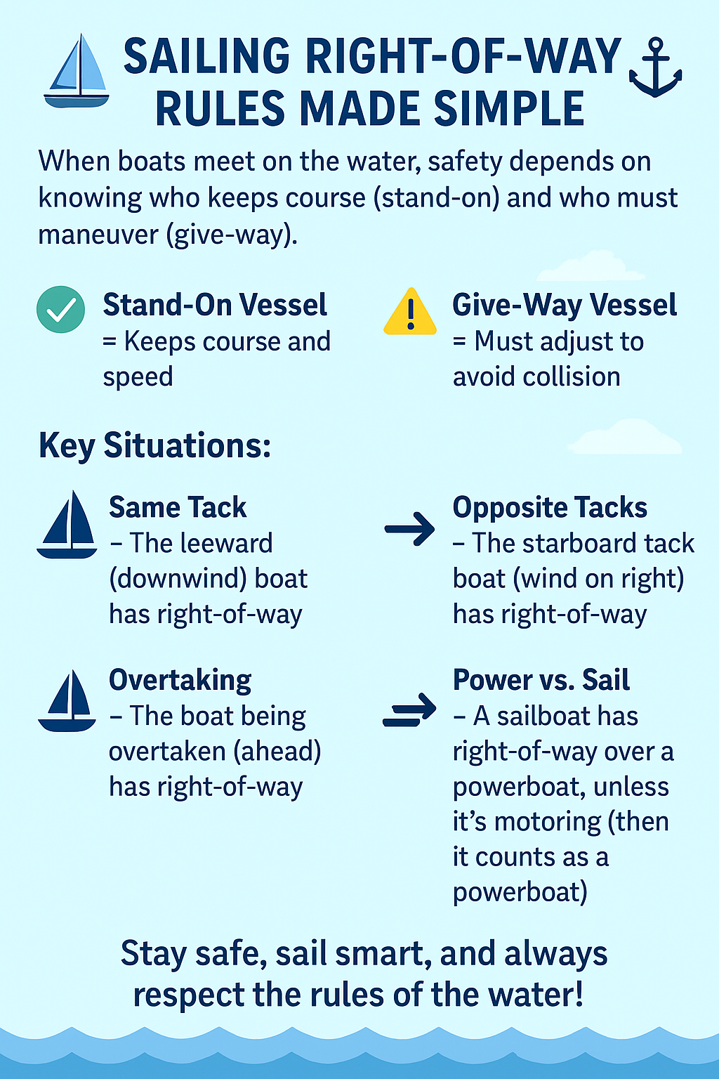
Sailing Right-of-Way Rules
| Situation | Stand-on Vessel (right of way) | Give-way Vessel |
|---|---|---|
| Boats on opposite tacks | Starboard tack boat | Port tack boat gives way |
| Same tack — different points of sail | Boat closer to the wind | Boat further from wind gives way |
| Same tack — windward / leeward | Leeward boat | Windward boat gives way |
| Overtaking | Boat being overtaken | Overtaking boat gives way — always |
Sound Signals
| Signal | Meaning |
|---|---|
| 1 short blast | I am altering my course to starboard |
| 2 short blasts | I am altering my course to port |
| 3 short blasts | I am operating astern propulsion (reversing) |
| 5 or more short blasts | Danger signal — I do not understand your intentions |
| 1 prolonged blast | Power vessel leaving a berth or approaching a blind bend |
Pre-Departure Checklist
Complete this checklist before every sail. Click each item to mark it done.
0 / 8 complete
- ✓Check NOAA weather forecast — VHF WX3 (162.475 MHz) or weather.gov/dtx
- ✓Verify current NOAA Chart 14850 is aboard or accessible on chartplotter
- ✓Inspect all safety equipment — PFDs, throwable, flares, fire extinguisher, horn
- ✓Confirm VHF radio is powered on and set to Channel 16
- ✓File a float plan with someone ashore — include destination, crew, and return time
- ✓Check fuel and engine oil levels; verify engine starts cleanly
- ✓Review current water level from NOAA Gauge 9044049 (St. Clair)
- ✓Brief all crew on MOB procedure and location of safety gear